Program Overview
Master of Science in Data Intelligence and GeoAnalytics Description
 The Master of Science in Data Intelligence and GeoAnalytics is a technology-enriched 36-credit graduate degree. The degree is intended to prepare learners with a solid foundation of hands-on technology to leverage new, exciting approaches in analytics and intelligence fields: 1) data acquisition, 2) data engineering, 3) principles of data science, and 4) geoanalytics and visual intelligence. These key areas are designed to provide a solid foundation in understanding technology, data development, data analysis, research, decision making, and presentation/communication skills vital for organizational effectiveness. Data intelligence provides insight to address questions about data: where to find it, how to assess it, what it means, how to organize it, how to display it, how to create meaning from it, how to leverage it for decision making, and how to share it. Geoanalytics provides a powerful combination of information and analytics with geographic information systems (GIS) to meet growing demands sought after in today’s market of integrated technology solutions.
The integration of data intelligence and geoanalytics is ideal for a wide range of data-rich fields, such as public health analytics, natural resource management, business applications, urban planning, public safety, public policy, political science, demographics, and government applications. For example, it is possible to assess impacts to healthcare populations by forecasting illness or disease outbreaks, such as influenza, that will escalate in geographic areas. Evaluating data intelligence on how outbreaks will respond makes it easier to strategize localized planning logistics for providing vaccines. In learning how to couple GIS technology with growing data intelligence capabilities, graduates will be more versatile in integrating technology and data science platforms, addressing issues, and solving real-world problems to generate more informed perspectives in decision making.
Program Outcomes: Upon completion of the program, students are expected to be able to do the following:
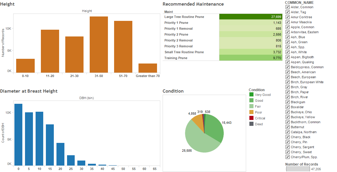
- Analyze geospatial data.
- Apply skills in data collection, data engineering, and database administration.
- Develop custom applications and scripts for visualization and analytics.
- Engage in complex critical thinking.
- Design effective projects and research.
- Communicate with clarify and coherence.
- Evaluate the ethical and legal implications of decision making.
From Start to Finish:
You can earn your M.S. in Data Intelligence and GeoAnalytics degree in less than two years.
Cohorts begin each fall, spring, and summer.
GIS Graduate Certificate Description
The Graduate Certificate in Geographic Information Science (GIS) is a technology-centered certificate program for those seeking professional geospatial technology skills to support increasing workplace demands for geospatial technology use and decision making. The certificate is comprised of 15 credits. Courses offered in the certificate parallel skills and knowledge needed for continued professional certification from the GIS Certification Institute. All courses are offered at the graduate level.
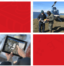
Learners are exposed to the latest software, technology, and resources for applied geographic information systems (GIS) and related technologies in fields such as natural resources, business intelligence, emergency management, surveying, urban planning, programming, public safety, and data management. In addition, experiences are enhanced by providing core training in operating GIS hardware/software, development of databases, GIS data analysis, and foundations of programming.
The program is structured to help maximize all experience levels and backgrounds - whether a person has a rich background in GIS or is completely new to the field. With geospatial technology’s ability to be applied to limitless fields and its increasing demand as a current and emerging career, it is a valuable science to possess within the digital technology era.
Program Outcomes: Graduates of the Graduate Certificate in GIS are expected to be able to do the following:
- Analyze geospatial data.
- Demonstrate proficiency in data collection and database administration.
- Develop custom applications and scripts for visualization and analytics.
- Engage in complex critical thinking.
From Start to Finish:
You can earn your Graduate Certificate in Geographic Information Science in less than one year.
Evening classes and blended/online learning formats fit a variety of schedules.
Cohorts have flexible start times in fall, spring, or summer.
Program Structure and Delivery
Courses in both the MS in Data Intelligence and GeoAnalytics and GIS Graduate Certificate are delivered in the blended format, integrating face-to-face classroom meetings and online activities or interactions in a planned, instructionally valuable manner.